
After a long pause, three words came to Luke Jacobsen’s mind while reflecting on his solo trek on the Pacific Crest Trail (PCT): “Phenomenal, hard and awesome.”
But, when Luke said “awesome” he took a moment to explain that he truly meant every bit of the word – as in breathtaking, imposing and awe-inspiring.
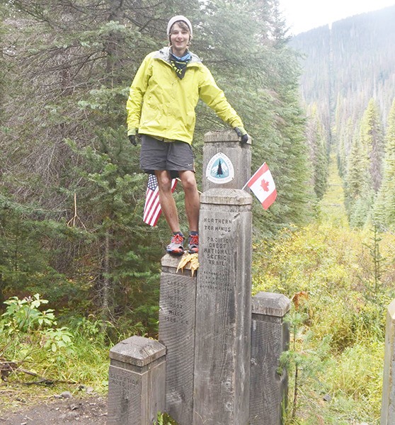
From 7:08 a.m., Wednesday, April 22, to 12:47 p.m., Tuesday, Sept. 15, Luke spent a total of 147 nights on the PCT, an infamous trail that spans between the U.S./Mexico and Canada borders.
Completing the trail, Luke walked 2,658 miles.
Along the trail Luke met numerous hikers, built relationships, suffered and healed from countless blisters, saw five black bears and encountered multiple rattlesnakes, hiked in 100-degree temperatures to areas with 3 feet of snow, turned 18 and was nearly brought to tears by the sheer beauty of nature.
Luke’s passion for wilderness began at his home just east of Sequim in Diamond Point. As a child, going on local hikes with his parents ignited his interest in nature, hiking and solitude. But it was really his three older siblings and their own appreciation for it that instilled in him a deep love for hiking.
Having grown up near Sequim, Luke has a special place in his heart for the Olympic Mountains with their “off the grid” presence, he said. Even after hiking through some of the most sought after and famous mountain ranges, the Olympics remain the most “wild and special” to him.
In hopes of inspiring others to get and enjoy the outdoors, here Luke shares a few snippets from his recent backpacking adventure.
“I love to backpack, I just graduated high school and wanted to get off the peninsula and experience some new scenery, so I thought it would be really fun to go hike 2,658 miles.
I started planning during Christmas break. I was going to school at Peninsula College so the whole bus ride there and back I would be planning the trip and each resupply point. It took a lot of time to figure how I was going to do it. There was a lot of logistical planning.
As soon as school ended, I had a week to get all my gear together and get packed up. My dad and I flew down to LAX (Los Angeles International Airport) and then rented a car and drove down to Campo, Calif., a little town right before the southern terminus.
It can be really hot down there in April, but I lucked out and it was only in the 60s.
Being a kid from the Northwest, I wasn’t looking forward to hot weather right away.
During my first couple steps northbound, I don’t know what I was thinking because Canada was so far away. You start walking day after day after day and anything you don’t need you just get rid of. My only luxury item was my camera.”
Getting started
“Mount Laguna was the first resupply stop. It was 43 miles from the start. The day before, I and everyone else on the trail got in a bad rain storm so everyone was drying out their gear there.
The first part of the trip had the most challenges … the first blisters forming and the worst night on the trail happened in the first week. That night there were 65 mile per hour gusts of wind and pouring down rain. I didn’t get any sleep that night, my tent blew over a couple times, everything got soaking wet … It wasn’t what you would expect in southern California.”
Trail angels
“Trail angels are just people that out of the goodness of their heart help hikers.
Our (mine and fellow hikers’) first trail angels were this couple that were reading that book ‘Wild’ so when they saw us, they popped out of their camper and asked if we were PCT hikers. They were really nice and fed us dinner and breakfast.
Hiking the PCT, you kind of realize how many nice people there are out there. People can get kind of depressed about society, but you hike this trail and you see that there’s still a lot of people out there that aren’t selfish and just want to help other people out.
The first real trail angel establishment was Ziggy and The Bear’s. They run a rest stop just for hikers from a house they bought because it was right next to the PCT. There, they have showers, food, places to wash your clothes, you can sleep and send packages there.
I don’t know why, but people along the PCT just want to help hikers out.”
First 700 miles and the Sierras
“The Whitewater Preserve was probably the most remote place I felt. It was kind of surprising that I felt the most remote in southern California … There was nothing out there.
Getting up into Tehachapi, it was getting into the 100s. Temperatures were just really hot, but the sunrises in the desert were unreal.
At the start of the Mojave Desert you could see so far that you could watch the rain travel across the horizon. It was simply beautiful, but also very monotonous at times.
Because the stretches between water sources are between 16 and 20 miles, at a typical spring there’s usually just a bunch of hikers chilling out and getting water.
There are ‘water catches’ — places where up in the middle of nowhere people pack chairs and gallons of water for hikers, but you don’t want to bet on anything being there. Still, it’s nice to stop and sometimes have some extra water and maybe fill a liter.
Overall, the first 700 miles to Kennedy Meadows, which is behind the Sierras, I didn’t have one pain-free mile.
Mile 702 is Kennedy Meadows and the biggest stoping point. If you make there, it’s like the gateway to the Sierras — you just made it though the desert and probably the toughest part of the trail and you’re about to go into the Sierras which everyone looks forward to.
During the first part of this trail you go all the way up to about 11,000 feet. My feet were getting worse — just nothing but blisters. Every mile something was hurting me. Either my feet were hurting or my muscles were hurting, but I still had a really great time.
Entering the Sierras you reach the highest point on the trail, Forester Pass at 13,200 feet and it was pretty unreal. The trail is just blasted out of the cliff face and was probably the single most pretty spot on the whole trail. I don’t usually cry, but I started tearing up because it was so gorgeous.
Muir Pass was amazing and though I’ve never been there, Evolution Valley was like Iceland to me.
Silver Pass was the last high pass before Yosemite.
We (me and a couple of befriended thru-hikers) climbed Half Dome. We started at about 3:45 a.m., so we could get the sunrise up there.
Half Dome was beautiful, but I think views from Clouds Rest were even better.
In the northern Sierras I had to wear a bug net because the mosquitoes were so thick. I’ve never experienced anything like it. The northern Sierras aren’t as dramatic, but still beautiful.”
Goodbye Cali, hello Oregon and Washington
“For me, the hardest part of the trip was hiking through northern California because it was pretty monotonous. You would go days seeing the same thing and then you come upon jewels like Burney Falls … things like that would keep you going.
The halfway marker was the most depressing point in the trail because you feel like you’ve been out there forever, yet you’re only half way. I just got a picture and walked on.
Unlike the halfway point, the California-Oregon border was a very happy moment.
California lasts for 1,698 miles so it’s the majority of the trip so once you’re out of California it’s like you’re almost there.
By the time I got to Oregon I was doing 25-30 miles a day. I started out doing 17 miles a day.
Oregon was nice because you could see where you were going. It made for pretty easy hiking.
The Cascade Locks mark the Oregon-Washington border … This was also a great day.
My family met me at White Pass. It was the first time I’d seen my mom the whole trip.
From there to Snoqualmie Pass I hiked in rain for two weeks straight. In those conditions, you just try to keep your sleeping bag dry and I had sleeping clothes in my sleeping bag, but everything else would get sopping wet. The worst part was getting up and putting on wet clothing in the morning.
From Snoqualmie Pass to Stevens Pass it was more of the same. When the clouds would open up, the view were unreal.
Finally by the time I got Stevens Pass (after taking a couple days off because of a fire closure) the weather had cleared up.”
The end
“The PCT gave me a good last day. It snowed and there was just a dusting of snow on the trail.
I had been on the trail so long that I was so ready to be done — mostly just because I wasn’t feeling very well because I had gotten food poisoning at one of the last stops.
By the time you’re three months into, it just becomes what you do. You forget about normal life. There’s a culture with thru-hiking. It’s hard to explain, but it’s a very friendly and unselfish culture.
It’s all psychological. Anybody can hike it. It’s just walking and you’ll get in shape as you walk.
The way I had to do it was when I stood at the border of Mexico, I just couldn’t think about Canada and how far away it was.
When you’re on the trail you only think about your next stop.”
Everyone has a story and now they have a place to tell it. Verbatim is a first-person column that introduces you to your neighbors as they relate in their own words some of the difficult, humorous, moving or just plain fun moments in their lives. It’s all part of the Gazette’s commitment as your community newspaper. If you have a story for Verbatim, contact editor Michael Dashiell at editor@sequimgazette.com

