
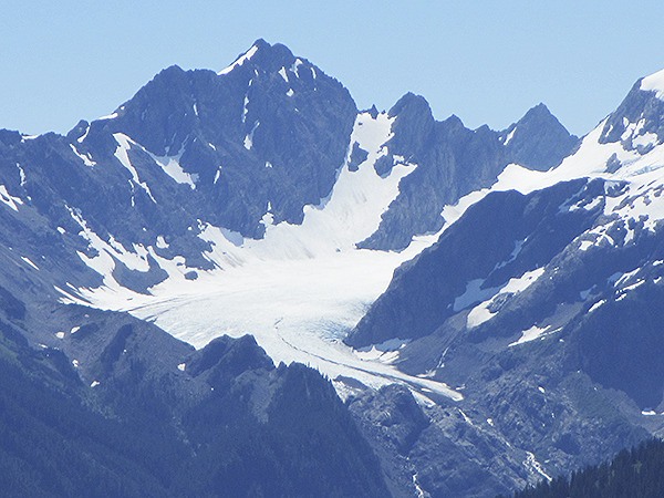
In my book, the view of Mount Olympus from the High Divide is one of the most glorious scenes anywhere, ever. We’re looking south across the broad Hoh River valley, but it feels like we could stretch an arm out and make designs in the Snow Dome with our finger.
The mountain spreads out before us in panorama, shining glaciers and snow fields filling the gaps between bony shoulders of dark rock. Jagged pyramids that form its triple summit lure us into guessing which is the highest, at 7,980 feet of elevation. Steep patches of evergreens drape its lower arms like a shawl, the forest nourished by massive waterfalls cascading to join the mighty Hoh River plowing through the cobble floodplain below.
It’s not too hard to imagine the Hoh as a 5,000-foot deep river of ice during the last Ice Age, plowing out the wide U-shaped valley we see now.
From the trail to Swimming Bear Lake, the vista is especially good of Blue Glacier, curling down the mountain’s east flank. The first notable feature is the color of the snow-free ice: cerulean blue, with stripes of black rock picked up by the conveyor belt of ice. Glacial ice literally carves and absorbs rock when the glacier is growing and receding year after year, millennia after millennia.
The next thing we notice are the multiple crevasses. My companions and I crossed that conveyor belt of ice in 2013 (roped together) on our way to the summit and now give thanks that what we can see was invisible to us then, safely covered with deep snow. We quickly stop trying to spot climbers, figuring no one would risk that route when those deep fissures are exposed.
Before us is geologic time in extreme fast-forward mode: When glacial ice melts more than it’s replenished with heavy snows that turn to ice, the glacier shrinks and its rate of carving slows. National Park Service scientists measured that Blue Glacier lost 325 feet in length in 20 years (1995-2006) and 178 feet of thickness (1987-2009).
The rapid shrinking of Blue Glacier is like the notorious ailing canary in the coal mine: It signals a consistent deficit of new snow and ice compared to prior decades. Apparently, the blanket of new snow we see each year hasn’t been deep enough or cold enough to match the power of the summer melting season and the net result is a very sick canary.
What does the Blue Glacier on Mount Olympus have to do with Sequim? In my book, everything. Sequim’s home watershed, the Dungeness, also has many astounding examples of glacial handiwork. With most of its peaks and ridges between 6,000-7,000 feet of elevation, only a few tiny remnants of Ice Age glaciers remain — and they’re getting smaller.
Meltwater from glaciers and annual snowfields is the water stored by nature, relied on in snowmelt season by people, farms and fish. At an upper elevation of 7,000 feet, these natural reservoirs are vulnerable to a warming climate because there isn’t much margin to work with. When the freezing level goes above 6,000-7,000 feet several times in winter, the snowpack will be compromised.
Almost year ago this column was started by a concerned resident, Jane Iddings, to bring awareness to the severe drought and future water supplies. This year, there is no drought declaration; however, our snowpack was again below average and our water resources, including streamflows, will be stressed until the dry season comes to a close.
It’s a good time to think twice before using extra water, especially outdoors. If you’re on an irrigation line your company or district could leave river water in-stream if you volunteer to conserve and let them know.
For the long view, it’s a good time to build resilience — and new storage is the best way to do that.
Geek Moment
In this area, the median freezing level elevation (since 1948) is 3,500-4,000 feet for December-March. If you track the freezing level that is usually broadcast with the weather report, and it isn’t below that elevation or doesn’t stay for long, you can predict that our snowfields and glaciers aren’t exactly growing.
Cumulative rainfall in Sequim for the water year (starting Oct. 1) = 19.7 inches (above average) (at Sequim Water Reclamation Facility, elev. 45 ft.)
Streamflow in the Dungeness River (on Aug. 4) = 235 cubic feet per second (less than average)
Sources: Olympic National Park, www.nps.gov/olym/learn; Freezing Level Tracker, www.wrcc.dri.edu/cwd/products
Ann Soule is a licensed hydrogeologist immersed in the Dungeness watershed since 1990. She now works for City of Sequim. Reach her at columnists@sequimgazette.com. This column was started by Jane Iddings, a concerned resident and part-time journalist, attorney, teacher and traveler.

