‘We are on a downhill slope’: Experts warn of Dungeness River’s shrinking lifeline
Published 4:30 am Wednesday, July 22, 2026
For generations, melting snow from the Olympic mountains has replenished the Dungeness River. In turn, it has maintained local farms, sustained fish, and supplied water to a growing number of lawns and gardens.
But the supply of snow that some might have considered endless… isn’t. Due to climate change, there is less and less snow, which means less water replenishing the Dungeness River.
The effects of that downturn have caused the local water lifeline to enter a precarious era that poses a risk to future generations, warns Barbara Vanderwerf, a member of the Clallam County League of Women’s Voters’ Water Committee. The purpose of the non-political committee is to facilitate a common understanding of water issues based on science.
“We are on the downhill slope of there being enough water to support a big population here in the Sequim–Dungeness Valley,” Vanderwerf said in a recent interview.
Local hydrologist Ann Soule, who spent years working for Clallam County and the City of Sequim, said the story of the Dungeness today is, at its core, a story about less snow in the mountains — and what that means for everyone who depends on the Dungeness River, directly or indirectly.
Is it a catastrophe playing out in real time? No. But to Soule it is a long, steady tightening of a system that has already been operating near its limits.
Snow ‘bank’
The Dungeness River, like most rivers west of the Rockies, is powered by winter.
Soule explained that historically the river has depended on two main sources high in the Olympics: annual snowpack and glacial ice in the Dungeness watershed. Each year, winter storms stack snow in the mountains. In spring and early summer, that snow melts in a predictable pattern.
“The hydrograph of the river flow over time… in the winter it spikes,” she said, describing the river’s typical pattern. “You have these storms and the river flows spiking. In the spring, it kind of calms down. The snow melt is a very constant thing, and so the river is nice and swollen and full in May, June, July, and then it starts ebbing.”
The rise used to be so reliable that fish, farms, and people arranged their lives around it. Salmon runs evolved to come upstream in late summer, when flows were still high enough to keep water cool and deep.
But in recent decades, that dependable pattern has begun to break down.
“When you start losing that snow in the mountains, whether it’s permanent glaciers or your annual snowpack, you’re going to have a lower peak or a changed peak, and that’s what we’re seeing now,” Soule said. “We’re seeing it in a serious way right now, because we’ve had these winters where the snow disappears from the mountains by June or early July instead of August.”
Years like 2015 — a notoriously low-snow “snow drought” — were once seen as extremes. Soule noted that in the last five years, conditions like that have become “not as extreme, but close,” and far more common.
Low flows, big consequences
Lower snowpack and earlier melt mean the river enters late summer with less water, and it runs low for a longer period of time, triggering a chain reaction.
The first to feel it are not lawns or city taps.
“I think people and wells are the last thing to be impacted,” Soule said. “It’s the farms and fish that are first.”
Salmon — long recognized by biologists as an indicator species — are a key signal of the river’s health.
“If these species of fish are impacted, that means the whole system is impacted,” Vanderwerf said.
Soule agreed, noting that salmon are a keystone species in the local watershed. When they return to spawn and die in the upper reaches, they bring nutrients that feed bears, birds, and other wildlife far from the mouth of the river.
“We would like to see salmon not go extinct,” she said.
Low summer flows also impact human demands. For more than a century, irrigators in the Sequim–Dungeness Valley were granted water rights that, collectively, exceeded what the river can physically supply in a dry late-summer season. Without realizing it, the state gave away more water rights than there was water in the river, Soule said.
Today, state agencies and local irrigators are trying to correct that imbalance. Farmers have voluntarily agreed to cut back when flows drop below certain thresholds. Taxpayers — through state programs — help pay some farmers not to use their full water rights so more water can remain in the river for fish and for long-term ecosystem health.
Meanwhile, thousands of private wells tap into the same connected water system.
Soule estimates there are “approaching eight to ten thousand” individual wells — “straws,” as Vanderwerf calls them — in the Sequim–Dungeness watershed, plus large municipal wells operated by the City of Sequim, the Clallam County Public Utility District (PUD), and nearby communities.
“It’s like the Old West water rights. Everyone’s shooting everyone up about water rights,” Vanderwerf said, speaking figuratively, “and it’s a big deal again.”
When gauges go red
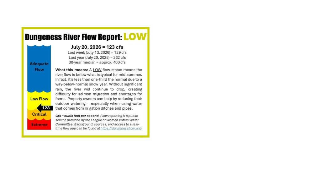
A technical graph of cubic feet per second may not resonate with most residents. That’s where a new public-awareness effort comes in.
Vanderwerf and Soule, who is also active with the League of Women Voters’ Water Committee, have been working with local partners to translate river flow data into something anyone can understand at a glance.
On roadside signs and in a companion smartphone app (Dungeness River Flow Monitor), the Dungeness River flow is now shown in color-coded categories: adequate, low, critical low, and extreme. The goal is to move beyond numbers and help people grasp what’s happening on the ground.
“Right now the flow is about 140 to 150 (cubic feet per second),” Soule said in an interview earlier this month, noting that the numbers put the river in the “low” range.
“Once it drops down to 120 it’s going to be critical low, and it’s just going to keep getting lower, and at some point this summer we might end up in the red.”
What does that red actually mean?
In internal materials Soule has drafted for agencies and partners, the highest alert levels correspond to real-world shutdowns. In the orange and red categories, irrigation companies that divert water from the Dungeness River may be forced to curtail or even completely stop withdrawals in order to keep enough water in the river itself.
“There is the possibility that somebody couldn’t water,” Soule said. “The blueberry farmers… they need an alternative.”
If diversions shut down while crops are still ripening, growers could face tough choices, including emergency pumping from wells or even trucking in water if they can, she said.
Though irrigation companies and farms are governed by water rights and formal rules, most individual well users are not.
“I have my well, I could have it running night and day, and no one could say anything, or no one would even notice,” Vanderwerf said. “It’s between me and my conscience as a good citizen.”
Drought in a ‘rainy’ place
One of the biggest hurdles, Soule and Vanderwerf believe, is perception.
People move to the Pacific Northwest expecting endless rain, Vanderwerf said — especially compared to places like Texas and the Southwest.
“People move here to the green, foggy, cloudy, rainy Pacific Northwest, expecting permanent, continuous ‘turn on the taps, leave them on when we brush our teeth, we’ve got water to spare,’” she said. “And particularly here in the rain shadow, there is really not water to spare, and it’s getting less and less.”
At a recent Dungeness River Management Team meeting — a group of agencies, tribes, purveyors and stakeholders — participants wrestled with how to communicate a difficult reality: for this region, drought is no longer an occasional emergency — it is becoming the norm.
“Yes, it’s a dry year. We’re going to have 70% of our years in the future be that,” Soule said. “This is not an unusual thing anymore.”
The challenge, she noted, is to deliver consistent messages to the public, even when some utilities rely on water sales for revenue and may be reluctant to discourage use.
“Why tell people to conserve when it means you’re going to be taking a cut in your revenue?” she posed. Ultimately, she said, “It’s an ethical or moral decision that must be made by, say, a political body, like a council. ‘We don’t care if we’re not going to be getting as much revenue. We need to tell people to conserve.’”
New feature
To reach beyond “the choir” — the already-engaged and knowledgeable gardeners, environmentalists, and policy wonks — the League’s Water Committee is partnering with the Sequim Gazette on a new regular feature.
The plan is to publish a simple, color-coded graphic showing the Dungeness River’s current flow status, along with a short explanation of what that status means and how the public can respond. For example, if the gauge shows “critical low,” a brief note might urge residents to:
• Skip lawn watering or reduce to once a week
• Avoid washing vehicles at home
• Check for and fix leaks
• Prioritize trees and long-lived plants over shallow-rooted grass
Soule noted that outdoor summertime use is where “all the mass consumption of water (for houses)” occurs. Indoor household use tends to be relatively stable; it’s irrigation that spikes in the dry months.
‘Good citizenship’
The message behind the weekly graphic and the color codes is that the aquatic cushion the community once enjoyed is shrinking.
“I think this would apply to good citizenship,” Vanderwerf said. “This is what we all have to do, because it’s a limited resource and they’re already good citizens, the irrigators… they’re doing what they need to do. But this is for the general public to understand.”
Soule, now retired from city service but still deeply involved in water issues, says the League’s Water Committee is one of the only local groups focused squarely on water supply and river flow.
If residents want to preserve the way of life that drew them to the Sequim–Dungeness Valley, they cannot assume the river will always be full.
“It’s to me really life-informing,” Vanderwerf said. “Because if we want to continue with our existence here on the North Olympic Peninsula, we’re going to have to really think about our water resources.”
For Soule, Vanderwerf and others sounding the alarm, the Dungeness River’s flow is not an abstract number on a graph. As snowpack shrinks and summers grow hotter and drier, that number is increasingly a measure of how well the community will weather the future — and whether the choices made at each kitchen sink, hose spigot, and irrigation gate will add up to resilience.

Best of Olympic Peninsula