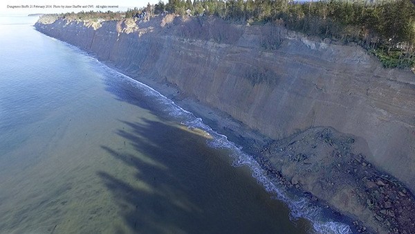
Bluffs are ‘melting’ away in Dungeness
Published 2:00 pm Wednesday, March 9, 2016
Mother nature is on the move.
Within the past few months the bluffs west of the Dungeness Spit have retreated more than 35-feet in some areas.
“Record rainfall has resulted in dramatic high bluff erosion this winter,” Anne Shaffer, Coastal Watershed Institute executive director, lead scientist and marine biologist, said. “What we’re seeing is exactly normal.”
Annual precipitation in Sequim jumped from its usual 16-17 inches to 23.07 inches, according to a 1980-2015 data set from Western Regional Climate Center.
However, the mechanism driving the erosion isn’t so much marine energy at the base of the bluffs, she said. Instead “water conveyance, including stormwater, nonpoint and septic issues associated with development” are impacting the stability of bluff tops.
“These bluffs are actively melting,” Shaffer said.
Bluff erosion is a natural and necessary process for ecosystem health, Shaffer explained. It provides a variety of ecosystem services like maintaining beaches, metering wave energy, providing forage fish spawning beaches and feeding and refuge for migrating salmon.
Sediment supply from coastal bluff erosion processes help to create landforms, including the Dungeness Spit, David Parks, Department of Natural Resources geologist noted in his recent publication “Bluff Recession in the Elwha and Dungeness Littoral Cells.” Parks has and continues to study local bluff processes.
“Where we see bluffs that are retreating properly we also see healthy beaches,” Andy Stevenson, Clallam County resident and retired marine geologist with the US Geological Survey, said. “It’s as simple as that.”
“Shoreline environments are critical and the ecological function these bluffs provide are important to everything — not just for salmon, but for our entire way of life,” he said.
Protection
“Bluff erosion is a processes that is supposed to happen, but when there’s a septic or oil tank or house associated with it that’s when you have a problem,” Shaffer said. Shoreline armoring is one practice used when trying to slow or stop erosion near developed areas.
“Shoreline armoring on these things doesn’t work,” Shaffer said. “These bluffs are too big and often aggravates the problem.”
Instead of trying to hinder erosion, Shaffer suggests implementing measures to protect bluffs and allow them to fulfill their ecosystem services. Part of protecting the bluffs is controlling what happens on and around them that could have impacts, like development.
“There’s a very clear relationship between saturation at the top of these bluffs and bluff activity,” Shaffer said.
Shaffer and her colleagues are just beginning to gather data on the recent erosion, but “we all know that development has direct impacts to surface and storm water,” she said.
Continued development of bluffs is admittedly a frustrating thing for Shaffer.
“We continue to see more and more homes allowed,” she said. “From our perspective the fate of those homes are clear.”
To fully protect bluffs and reduce risks associated with building homes on unstable land, the right tools need created given many bluffs are developed, she said. Already some landowners have had to take action to avoid danger from erosion.
“It’s an ongoing discussion how to best fund it,” but Shaffer is trying to secure grant funds for a pilot project aimed at creating a funding pool for “bluff stressed property owners.” Another option is a protection tax, similar to a public utility district or flood protection district.
Creating the tools to give people “an out,” Shaffer said, would help existing landowners relocate further from the bluffs and in-turn help protect themselves and the bluffs.
Shoreline Master Program update
Bluffs and development on them are addressed in the Clallam County Shoreline Master Program under review by the county Planning Commission.
The program provides county officials with information and regulations needed to manage bodies of water and adjoining shoreline in areas where people live, work and recreate, Steve Gray, Clallam County Department of Community Development deputy director and planning manager, told the Gazette in a past interview.
“It focuses on striking a balance between development and economic growth while preserving our unique shorelines and the ecological functions and services they provide,” he said.
Once revised, county staff plan to host regional educational workshops on the program.
Staff have steadily worked on the Shoreline Master Program November 2014 draft since 2009. The program was slightly updated in 1992, but otherwise the it hasn’t undergone a comprehensive review since adopted in 1976.
The recent update is behind schedule, but Gray anticipates having it to the Board of County Commissioners by late summer, where it will undergo a local adoption process before final adoption by the Washington State Department of Ecology.
Research from scientists like Parks was included in the update, Gray said, and influenced the distances (setbacks) a landowner can build in relation to the bluff edge.
“The minimum is 150-feet, but whenever possible we encourage people to build further back,” Gray said. “It’s a question of when, not if the bluffs are going to continue to erode.”
Despite the known impermanence of bluffs, the county doesn’t have the “justification” to outright eliminate all development on bluffs or make existing homeowners move, Gray said. Instead “we want to increase the buffers, not just for safety, but for new development and to minimize impacts to the drift cells,” he said.
Increasing safety precautions isn’t sufficient to Stevenson.
“There are areas currently developable that really need to be redlined, but the county isn’t willing to create a regulatory environment where somebody is going to get hurt,” he said.
“You can’t deny geology,” he said. “To me, it’s cheaper to fix it now than later.”
Stevenson spent 32 years with the USGS working in different areas and coastlines and brought that experience to the table during the Shoreline Master Program update as a member of the technical committee. The committee consisted of about 30 people, all with diverse backgrounds and perspectives, he said.
“It was very clear to me all the way through the process that this is an extremely contentious issue,” he said.
Stevenson walked away from the update process “disappointed,” he said, as he feels the program it doesn’t accomplish its goals.
His biggest concern with the program is it uses an erosion average of 1-foot per year for planning purposes and establishing setbacks.
“I don’t think it’s a good number,” he said. “I think today’s number is more like 2-feet a year.”
Feeder bluffs west of the Dungeness Spit don’t erode at a regular rate, but are episodic, which make it difficult to conclude the rate of erosion from year to year, Stevenson said.
“Geologists have two different senses of time,” he said. “There’s the geologic calendar and then there’s the human life span.”
By studying the past 5,000 years the bluffs erode on average about 1-foot per year, but when “we’ve started to look at that the short term rates they are pretty much double that one year average,” he said.
So, the question becomes what has changed within the past 5,000 years? The answer is “a lot,” Stevenson said.
“There are many factors at play and they all have an affect (on bluff erosion),” he said.
The data ins’t available to “pinpoint” one action or more likely actions impacting erosion, Stevenson said, but “what is clear is that things have changed and we’re seeing an increase in erosion rates.”
For information on the county’s Shoreline Master Program update, visit www.clallam.net/LandUse/SMP_CurrentDraft.html. Publications by Parks can be seen at, www.researchgate.net/profile/David_Parks.