
For the next six weeks scientists will scatter throughout the Olympic Peninsula by land and the air gathering data on the area’s storm events with a particular interest in rain and snow.
The data collected won’t only deepen the understanding of weather and potentially the ability to monitor storm events, flooding and drought, but the research is aimed at assessing the function of the Global Precipitation Measurement (GPM) mission.
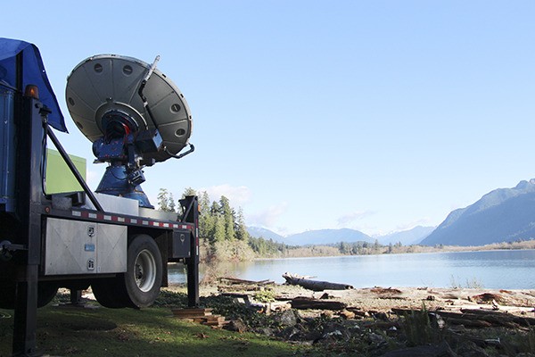
To validate the GPM, scientists are taking a variety of ground measurements using both ground- and aircraft-based radars, passive microwave instruments and airborne microphysical sampling. The effort led by NASA in collaboration with the University of Washington and the National Science Foundation, among others, is known as OLYMPEX, or the NASA Global Precipitation Measurement Mission Olympic Mountains Ground Validation Experiment.
The core satellite of GPM intended to measure rain and snow globally, especially in areas where little is known, was jointly launched in February 2014 by NASA and the Japan Aerospace Exploration Agency.
“The GPM constellation of satellites must be able to detect solid and liquid precipitation over a large range of intensities and a wide range of regimes,” according to the OLYMPEX Ground Validation Experiment Field Operations Plan.
The ground validation field campaigns are “vital” according to the OLYMPEX plan when trying to determine the accuracy of the mission’s equipment and how to apply the collected data.
Measurements being made
Under OLYMPEX, a concentrated window of data collection kicked off Nov. 10 and will continue through Dec. 22, where three types of aircraft with varying capabilities for data collection will be used in collaboration with a handful of radars and ground-based sensors.
“Most of the radars will be operating all the time, but the aircraft are tied to decisions made from the operations center on whether it’s worth flying,” Lynn McMurdie, UW Department of Atmospheric professor and co-project manager of OLYMPEX, said. “We’re mostly going to be flying during storms.”
Although larger storms typically have a lot of rain and thus ensure the ability to get good measurements, McMurdie explained, it’s also important to fly the aircraft and take measurements during a variety of conditions.
The intensive, aircraft-dependent aspect of OLYMPEX is under way, but the field campaign is scheduled to run through next winter with an Operations Center at the UW where the project’s overall components and daily operations are managed.
OLYMPEX is the last of a handful of ground validation field campaigns in support of the GPM satellite program.
McMurdie has been involved with OLYMPEX for about four years, but others like Robert Houze, professor of Atmospheric Sciences at UW, have been involved with the field campaigns for much longer, she said.
“When we first started doing the ground validation campaigns it was decided to come here (Olympic Peninsula) last because it’s the most complicated,” McMurdie said.
Examples of other GPM ground validation field campaigns include the Iowa Flood Studies in 2013 in northeastern Iowa, the 2012 Midlatitude Continental Convective Clouds Experiment in central Oklahoma and the 2012 GPM Cold Season Precipitation Experiment conducted over and near the Ontario, Canada, and the Great Lakes.
Ideal location
But, when it comes to studying storms and testing GPM satellites’ ability to obtain a wide variety of data on snow and rain, the Olympic Peninsula is “ideal,” according to the OLYMPEX plan.
“In one compact area, the Olympic Peninsula ranges from ocean to coast to land to mountains, where the terrain height ranges from sea level to elevations over 2,000 m (meters) over a distance of approximately 50 km,” according to the plan. “OLYMPEX will be able to monitor the storm characteristics and processes over the ocean, their modification over complex terrain and the resulting hydrologic impacts.”
The varying and unique geography of the peninsula make it both ideal for the field campaign as well as challenging because of some of the remote areas accessed, including portions of Olympic National Park.
The majority of data will be collected in and around the Quinault and Chehalis river basins given they’re located in the wetter southwest side of the Olympic Mountains. Thoughtfully placed radars and ground instrumentation are being used to sample storms as they approach from the Pacific Ocean and morph to pass over the higher elevations.
Still, the drier, leeward side located to the north and northeast of the Olympic Mountains, including the Sequim area, is an part of the field campaign.
“There’s stuff on that side, too … don’t think we have forgotten you,” McMurdie said, referring to the residents of Sequim.
Those involved with OLYMPEX have installed temporary equipment on the leeward side of the mountains in and around Hurricane Ridge, including a small radar capable of recording the speed of falling raindrops and an instrument that takes high-speed photographs of the crystals of falling rain or snow.
Additionally, McMurdie said, the project partner Environment Canada has a radar on Vancouver Island directly north of Sequim that looks toward Hurricane Ridge. The radar measurement taken from Environment Canada will help document the “leeside” processes.
“People get very exciting when field campaign happens, but the real work really occurs afterward,” McMurdie said. “The hard part is making measurements that will be good later.”
Community contributions
Other information anticipated to be helpful when compiling all the data and measurements following the field campaign is the data collected from local residents and volunteers within Clallam County, McMurdie said.
“A lot of people with the Community Collaborative Rain, Hail and Snow Network are in the Sequim area,” she said.
The network is a nationwide nonprofit, community-based network of volunteers of all ages and backgrounds working to measure and map precipitation with low-cost measurement tools. The measurements collected from volunteers are then loaded to a live data base and map at www.cocorahs.org.
In Clallam County, Jeff Michalski reports 50 residents are registered volunteers with the Community Collaborative Rain, Hail and Snow Network.
However, since OLYMPEX began, there’s been an increase in interest, he said.
Michalski, with the National Weather Service, is the regional coordinator for the western Washington Community Collaborative Rain, Hail and Snow Network.
“Since early October, we’ve gotten a couple new observers a week,” he said. “The Community Collaborative Rain, Hail and Snow Network helps to provide a denser set of calculation.”
For more information on OLYMPEX, visit olympex.atmos.washington.edu or pmm.nasa.gov/olympex.
Reach Alana Linderoth at alinderoth@sequimgazette.com.

