Study suggest long-term groundwater declines
Published 11:49 am Wednesday, March 30, 2016
According to a new state study, Sequim is seeing less and less water in the ground, and local experts say one of the area’s hallmarks — irrigation — is at the root of the downward trend.
As the primary manager for Washington’s water resources, the State Department of Ecology has long collected data from wells to monitor, among other parameters, groundwater depths.
Earlier this month, state officials released the report, “2015 Drought Response.” It included a preliminary analysis of how groundwater storage in Washington aquifers responded to reduced snowpack and emergency increases in groundwater pumping.
Drought, first declared last March, dubbed in the summary report as the year of the “snowpack drought,” is spurring the groundwater research. Given warmer-than-average temperatures from October 2014 through March 2015, Washington received record low snowpack as precipitation that normally falls as snow instead fell as rain.
Based on climate change predictions, lower winter snowpack, as experienced last year, is “likely to become more common in Washington,” according state officials.
Information gleaned from evaluations, like that on groundwater levels, are intended to help inform water management during future periods of reduced snowpack as precipitation shifts in its form of delivery.
The study
To begin to understand how groundwater responded to the snowpack drought, researchers with DOE evaluated groundwater measurements collected in 2015 from 264 wells across the state, including a handful of wells in Sequim and Agnew. Only two wells in Agnew had water levels that “consistently fell below the wells’ normal water level range,” according to the analysis.
Overall, the groundwater levels in western Washington ranged monthly from slightly above to slight below normal.
“Collectively, these data suggest the drought had little overall impact on groundwater levels/storage in monitored wells west of the Cascades,” according to DOE.
However, “There is reason to be concerned about the sustainability of groundwater levels/storage on the east side of the mountains, particularly in the greater Yakima and Columbia basins.” Throughout last spring wells in both basins were below normal or at the lowest levels ever measured before the drought peaked.
As DOE officials turned their attention from last year’s groundwater measurements and combined them with historic measurements, the data suggests long-term, wide-spread declines.
Nearly all wells, including the two wells in Agnew, that set record low depths in 2015 also reflected downward water level trends over time. Mirroring the short-term evaluation on groundwater levels, the long-term declines were amplified in the Columbia and Palouse basins.
“In these areas average groundwater declines of 1.9- and 0.66-feet per year have been documented,” according to the analysis. “A similar pattern was noted in water levels of a few wells near Sequim.”
Localized look
Of the 11 wells in Sequim and Agnew included in the initial “2014-2015 Drought: Groundwater Level/Storage Response” evaluation done by DOE, only one reflects an upward trend. Though, given how slight the trend is and the deep depth of the well, Ann Soule, City of Sequim water resource specialist, questions whether it could really be considered an upward trend, she said.
Locally, groundwater provides a reliable source for individual well owners and community wells that serve the city, but also developments like Sunland and the Clallam County PUD in Carlsborg, Soule said. Not only is it reliable, but it’s relatively clean because it’s naturally filtered by the soil.
However, Soule notes, nitrates have built up in the groundwater system and are an indicator of land use impacts on groundwater quality.
Ecologically, groundwater plays an important role. “The small streams around here exist only because of groundwater discharge,” Soule said.
The reasons for the long-term downward trend in the Sequim-Dungeness Valley’s groundwater levels are tightly linked to the evolution of irrigation.
“Hydrology in the Dungeness watershed has changed tremendously over the past century because of irrigation,” Joe Holtrop, Clallam Conservation District executive director, said. “Flood irrigation, which was the only method of irrigation for about the first 50 years, had the biggest impact.”
Hundreds of acres throughout the valley couldn’t be farmed because flood irrigation caused an “artificially high” water table, he said. To help, drainage systems like tile drainage were installed.
By the 1950s, irrigation practices were moving from flood to sprinkler systems, he said. Groundwater levels started to return to a more normal depth after the piping of open irrigation ditches.
“Ditch piping is largely responsible for getting the shallow aquifer back to a natural state,” Holtrop said.
The shallow aquifer is one of three main aquifers, along with the middle and deep, identified in the vicinity of Sequim.
Coinciding with shifts in irrigation techniques, “thousands of wells have been drilled over the decades and they’re having impacts,” too, Holtrop said.
Some of the data used by DOE to plot the long-term trend of local wells date back to the mid-1970s. During that time there were very few water conservation techniques being implemented, Soule said. By the late 1980s and early 1990s, irrigators increased conservation efforts to keep more water in the Dungeness River, like piping the ditches.
To maintain surface water flows and groundwater levels is a balancing act.
“There’s a direct trade off,” Soule said. “There is so much more connectivity between our surface and our groundwater in this area … more than you can see or tell.”
A balance
To help ensure groundwater levels for both for human and environmental use, a handful of water management efforts are underway.
“It’s all about timing and control,” Holtrop said.
The piping of irrigation ditches conserves surface water and keeps it from being lost to the ground during late summer and low stream flows.
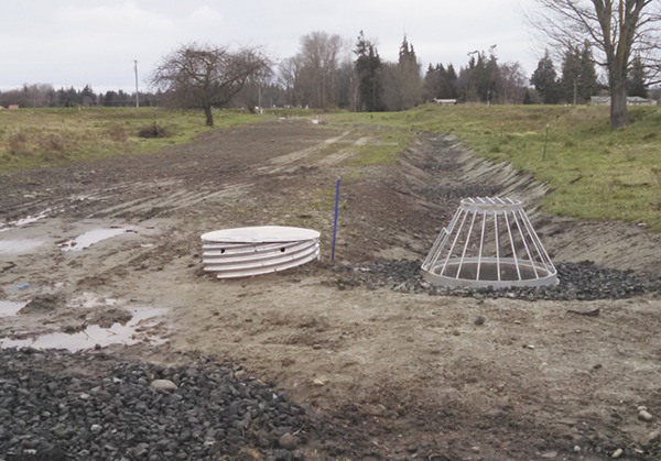
However, during late spring and early summer when the snowmelt is occurring and stream flows are high, aquifer recharge sites can be used to divert water and allow it to infiltrate back into the ground before being lost to the sea. The water infiltrated into the shallow aquifer can help offset well withdrawals and natural surface water losses later in the summer, according to an “Aquifer Recharge Project Update” by the Clallam Conservation District.
“With irrigation pipelines and strategically located aquifer recharge sites we can have the best of both worlds — no ditch losses when water is scarce and infiltration of water into the shallow aquifer when it is plentiful,” according to the update.
The Clallam Conservation District recently completed two aquifer recharge projects, including one along Carlsborg Road and another near McComb Road, by installing perforated pipe, drain rock and small dams to enhance infiltration. Both projects are ready for implementation this spring, Holtrop said.
Another aquifer recharge project near Robin Hill Park is in the design phase. The Agnew Irrigation District will construct, own and operate it.
Two of the projects aim to mitigate new exempt wells and one is intended for general recharge to benefit Matriotti Creek and the Dungeness River, Holtrop said.
The Clallam Conservation District also promotes water conservation mainly with homeowners and their landscapes.
Also, the first Storm and Surface Water Master Plan for the City of Sequim undergoing the adoption process is supportive of groundwater recharge. A public hearing on the plan is scheduled for 6 p.m., Monday, April 11.
“The plan is very encouraging of infiltration to replenish the groundwater system, make use of that water and store it,” Soule said. “Storage is my new mantra.”
In the Sequim-Dungeness Valley “wells may need to be deepened,” Soule said, but compared to other areas like Nebraska and its surrounding states that heavily rely on the Ogallala Aquifer, “we’re in good shape.”
Communities in Nebraska are truly “mining” their groundwater and don’t have a plan for compensating for that, she said.
For Washington, the recent summary report is a start, but DOE officials admit they’re still working to fully understand potential impacts of the 2015 drought — especially in eastern Washington where extensive pumping of groundwater for irrigation and other purposes occurs.
Researchers with DOE plan to build on the preliminary evaluation on groundwater levels. An update to the findings are expected early summer. The update will include groundwater level measurements collected now through April, prior to the start of the 2016 irrigation season. For the Sequim-Dungeness Valley, the irrigation season spans April 15-Sept. 15.
The summary report, groundwater data and drought monitoring updates can be viewed at www.ecy.wa.gov/drought.
For Water Supply Availability Committee meeting information and agendas, visit www.ecy.wa.gov/drought/wsac.html.