Studying the impermanence of bluffs
Published 10:26 am Wednesday, June 18, 2014
A four-year cooperative study will draw to a close at the end of this month, but the beginning of many more years of research is just beginning.
David Parks, geologist with the Department of Natural Resources, embarked on data-collecting journey July 2010. Parks has since walked the studied sections of coastline countless times investigating coastal bluff processes.
The study involved a variety of organizations such as the Department of Ecology, Environmental Protection Agency, Washington Department of Fish & Wildlife, Clallam County Marine Resources, Coastal Watershed Institute and Peninsula Community College and Western Washington University interns. Both the Clallam County Marine Resources Committee and Environmental Protection Agency funded the study with grants.
“One goal was to better understand the sediment budget for the nearshore and how much sediment comes from the bluffs,” Parks said. “We also looked at rates of bluff recession.”
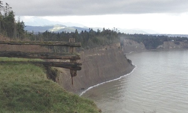
Clallam County is nestled between the Olympic Mountain range and the Strait of Juan de Fuca. With the northern border of the county a coastline, parts of it consist of actively eroding bluffs left behind by retreating glaciers thousands of years ago.
Despite the instability of bluffs, they still tend to be a desired location for homeowners given the breathtaking views bluffs provide. In attempt to slow erosion and thus prolong the safety of nearshore infrastructure, shorelines often are “armored.” And although armoring may slow erosion, it does not stop it and it influences the connection between bluff erosion and habitat-building processes that create accretionary landforms like the Dungeness Spit, which is primarily maintained by the sediment from the west, Parks said.
The study
Studying the Elwha and Dungeness drift cells (section of coastline with a net sediment source with an input of sediment and a zone of transport which then moves the sediment to a deposition area) helped Parks and involved parties understand the complexities of bluff erosion which is important for both ecological and planning reasons. Past studies of local bluff erosion are “hard to apply generally” because each study unfortunately used different methods and scales, Parks said.
“We were really interested in getting accurate numbers to fill the gap in data,” Parks said.
In order to piece together a timeline for the bluff erosion at each drift cell, Parks repeatedly gathered GPS measurements by foot at the same locations bimonthly for four years. This arduous method gave Parks the information to create cross-shore beach profiles. Parks coupled his data with digitized historical aerial photographs and nearshore beach profiles collected with both airborne and boat-based LiDAR technology. The boat-based LiDAR was developed specifically for the study by the Washington State Department of Ecology, Parks said.
“With one exception west of Port Angeles, all profiles have net erosion where beaches are losing sediment and the beach profiles are lowering,” Parks said. “They are widely spaced profiles, but are a convincing representation of the trend.”
Based on Park’s data, the bluffs within the Dungeness drift cell are receding at a faster rate than the bluffs within the Elwha drift cell.
“Where you have a high rate of sediment loss on the beach you also have a higher rate of erosion on the bluffs,” Parks said.
The 2001-2012 average rate of bluff recession within the Dungeness drift cell is 0.36 meters per year, or slightly more than 1-foot per year. Whereas the 2001-2012 average rate of bluff recession within the Elwha drift cell is 0.26 meters per year, or slightly under 1-foot per year.
“A lot of people don’t have any concept of how fast these rates are,” Parks said.
The information from this study is intended to aid county officials update the Shoreline Master Program. Although the program was revised in 1992, the original program dates back to 1976.
Community development and planning
The Clallam County building code “requires that structures be set back a distance equal to the height of an unstable bluff not to exceed 100 feet,” according to the Clallam County website. The Clallam County Shoreline Master Program and the Critical Areas Ordinance also establish setbacks from all shorelines that range from “35 feet to 200 feet depending on the classification of the fish and wildlife habitat or the shoreline environment designation.”
The building codes that supposedly err on the side of caution have not kept bluff erosion from impacting county resident and coach for Port Angeles boy’s soccer team, Chris Saari’s home.
Saari bought his 1970s home located within a bluff subdivision near Gasman Road between Sequim and Port Angeles nearly 18 years ago. Late February of last year a landslide occurred prompting Saari to begin the task of moving his house away from the eroding bluff.
“I knew I would probably have to move the house at some point, but looking back I am not sure I would do it again,” Saari said.
Fortunately for Saari he has the space to move the house back farther from the bluff and from where the house is now, which is only about 17 feet since the landslide. Unfortunately, the process is expensive Saari said. There’s the cost of moving the house, building a new foundation and installing a new septic system.
Two additional areas with houses in close proximity to the Dungeness drift cell that includes the stretch of coastline between Morse Creek and Dungeness Spit are the Monterra community and Gehrke Road, Parks said.
The technique of “armoring” doesn’t stop erosion, it at best it only slows it, and often increases erosion (including down drift of the armoring), said Anne Shaffer, director of Coastal Watershed Institute and a marine biologist. Thus, in many ways research appears to suggest heavy armoring is not an ecological or economical sustainable practice.
Parks’ data did in fact identify that the heavily armored areas of coastline are undergoing slower erosion rates, however “anything that interrupts wave energy or sediments is potentially problematic from an ecological standpoint,” Parks said.
Ecological importance
Unrestricted drift cells are able to erode and supply the sediment needed for transport along the coastline to provide material for beaches and habitats. This natural process provides the necessary needs for a variety of ecological processes, including proper spawning conditions for forage fish such as smelt and sand lance (two examples of local forage fish species).
“Forage fish are a key prey base for iconic species, like salmon and marine birds,” Parks said. “They (forage fish) need specific grain sizes to be able to spawn successfully.”
Thus, the erosion and movement of sediments along the coastline can influence the health of nearshore ecosystems. In addition, the interaction between drift cells also has proven important.
Without the Dungeness drift cell, the Dungeness Spit could be lost, Shaffer said. The Dungeness Spit not only has recreational value, but it creates Dungeness Bay.
The Elwha and Dungeness drift cells differ in their characteristics. Most noticeably, 68 percent of the Elwha drift cell is armored compared to less than 1 percent of Dungeness drift cell, Shaffer said. Feeder bluffs of the Elwha historically provided more than 60 percent of sediment to the nearshore, including Ediz Hook (the spit in the Elwha drift cell). Because the majority of feeder bluffs within the Elwha drift cell are now armored, Ediz Hook is severely sediment starved. In contrast, Shaffer said the Dungeness drift cell has little armoring and no impaired sediment sources — and Dungeness Spit is growing on its own.
Elwha drift cell and Ediz Hook provide the opportunity to understand what armoring does to shorelines and comparing and contrasting different nearshore management practices with an eye to the best future plans, Shaffer said.
Build on research
“The next step is to relate beach sediment volume changes to bluff recession rates so we can begin to understand how lowering the beach influences bluff erosion,” Parks said.
Although the grant for the four-year study has come to a close, Parks plans to continue to gather post Elwha dam removal data for future use and to provide a consistent baseline of geologic information.
“It’s important to know what’s happening at the Elwha delta, but also important to know what’s happening east and west of the river,” Parks said.
Reach Alana Linderoth at alinderoth@sequimgazette.com.