
Along with project partners, county officials are nearing the design phase for replacing a 1960s-era levee, allowing the Dungeness River to use its historic floodplain, restore habitat and reduce flood risks.
Habitat biologist for Clallam County Cathy Lear said “it’s pretty exciting” to be moving on from the preliminary planning phase and into the design phase of a restoration project to setback a portion of the levee along the east side of the lower Dungeness River.
County officials have slowly moved forward with the project for nearly a decade, Lear said, but noted she is “delighted” that within the past five years there’s been “real action.”
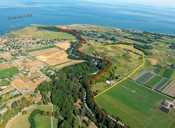
Completed by the U.S. Army Corps of Engineers, a feasibility study evaluated the various setback options to reconnect an estimated 4,800 feet — or slightly less then 1 mile — of the river to 112 acres, stretching between the northern boundary of the Dungeness Valley Creamery to just upstream of the Dungeness Schoolhouse. The study took into consideration the hydrology, topography and use of restoration techniques such as engineered log jams and side channels.
With the release of the feasibility study mid-January county officials will begin designing the final levee using a $1.5 million state grant from Floodplains by Design.
The release of the feasibility study also will open the door for a 30-day public review and is considered a “valuable” part of the project by USACE Project Manager Leah Wickstrom.
Wickstrom said she realizes residents often know things about the project area that planners may not.
The project isn’t expected to break ground until 2016 or 2017, but Wickstrom said, “We’re nearing the end of a significant portion of the project.”
Clallam County and USACE officials entered into a cost-share agreement in 2011 after county officials approached the corps about getting involved. Additionally, the USACE officials are able to fund up to $5 million of the project under section 544 of the Water Resource Development Act.
Throughout the feasibility phase, the county and USACE have evenly shared costs, but moving ahead 65 percent of the project cost will be federally funded through the USACE, contingent on funding approval, and the county’s responsible for the remaining 35 percent, Wickstrom said.
Lear estimates the total cost of the levee setback restoration project at $11.8 million, but the amount may fluctuate with progression of the project.
The existing USACE levee built in the 1960s was constructed to control the river, but “we know more now and know how important a healthy river system is,” William Dowell with USACE’s public affairs, said.
The lower portion of the Dungeness River has been restricted between both federally and privately owned levees, and has thus become faster, dropping more gravel because it’s unable to naturally flow and meander and slowly transport sediment along the way. In turn the river is now elevated above its floodplain which actually increases the flood risk, Lear said.
“That portion of the river can be very deadly to fish,” she said.
Chinook salmon, summer chum, bull trout and steelhead are among the fish that rely on the river and are all federally listed on the Endangered Species Act.
“One of the things I would like to do is an ecosystem service analysis because these days you can actually start to quantify what that means,” Lear said. “I think that we will see a net gain in ecosystem services so we’ll also likely see better water quality, less flood risk and a place where fish can thrive.”
Although the project area used to be privately owned, throughout the years various agencies, including Washington State Department of Fish and Wildlife, Clallam County and the Department of Transportation, have purchased the majority of the surrounding land, Lear said. The property owned by DOT was to mitigate for the construction that encroached on other wetlands while recently widening U.S. Highway 101.
The amount of collaboration between a diverse set of agencies is somewhat unique and not always the case in many counties, Lear said.
“This area has a tradition of working together,” Lear said. “The project area is so rich in natural resources and an amazing floodplain. It’s a special place and it’s being recognized.”
Reach Alana Linderoth at alinderoth@sequimgazette.com.
